

 GO BACK
The GFZ Helmholtz Centre for Geosciences is the national research centre for Earth sciences in Germany. Research at the GFZ focuses on the geosphere within the highly complex System Earth with its further subsystems, its interacting subcycles, and its wide network of cause-and-effect chains. This is done in close interdisciplinary collaboration with the related scientific disciplines physics, mathematics, chemistry, and biology as well as with the engineering sciences disciplines of rock mechanics, engineering hydrology and seismology.
Harnessing Big Data to Decode Earth’s Dynamics
In particular, GFZ covers a broad range of temporal and spatial scales of geological processes from deep Earth’s interior to the near-Earth space by observation and modelling and integrates fundamental and applied research in the geosciences. We develop and integrate state-of-the-art approaches to the management and analysis of big digital data for the imaging of the subsurface with geophysical methods and drive event forecasts and hazard and risk models. Examples are earthquake and volcanic processes and their effects on Earth’s surface and our habitat, including the potential drivers reaching deep into mantle geodynamics.
Coordinating SENSEI WP2: Real-field tests and characterization of new photonic sensing devices
SENSEI will develop techniques to probe fibres already in use for data traffic, fitting the network’s architectural constraints without causing service disruption. Furthermore, it will design dedicated protocols to handle data collected by a heterogeneous set of sensing elements and integrate them into the network control architecture. This is a crucial step towards extracting exploitable information from a huge volume of data.
To demonstrate relevant use cases, SENSEI will have access to thousands of kilometres of fibres deployed in various environments, ranging from the Mediterranean Sea to volcanic and seismic areas in Italy and Iceland, but also aerial cables and telecommunication networks in metropolitan areas. The consortium partners will rely heavily on existing infrastructures used by National Metrology Institutes to carry precise time signals, such as the Italian Quantum Backbone in Italy and Refimeve in France. SENSEI will involve commercial operators and network providers.
GFZ is in charge of the coordination of Work-Package 2 (WP2), meaning the implementation of the developed techniques, such as new photonic sensing devices, in various real-field scenarios, ranging from urban areas to seabeds, and highly seismic regions. GFZ will search for signatures of various events, targeting continued acquisition, autonomous event recognition and advanced processing. In collaboration with ISOR (other partner of SENSEI), GFZ will focus on the Iceland test-site, Reykjanes Peninsula (Jousset et al., Reykjanes, Iceland: Structure and dynamics of mid-oceanic ridge geo/hydrothermal systems, 2020).
Ongoing experiments in Iceland: already two eruptions measured and recorded
The team of GFZ has been interrogating a dark optical fibre within a 15 to 21 km long cable deployed in 1994 for telecommunications between two power plants (Reykjanes and Svartsengi), which was shown to be valuable to record earthquakes and image subsurface features.
Read about it:
- Jousset et al., Dynamic Strain Determination Using Fibre-Optic Cables Allows Imaging of Seismological and Structural Features, Nature Communications (2018)
- Flóvenz et al., Cyclical geothermal unrest as a precursor to Iceland’s 2021 Fagradalsfjall eruption, Nature Geosciences (2022)
- Maass et al., Stacking of Distributed Dynamic Strain Reveals Link Between Seismic Velocity Changes and the 2020 Unrest in Reykjanes, Journal of Geophysical Research (2024)
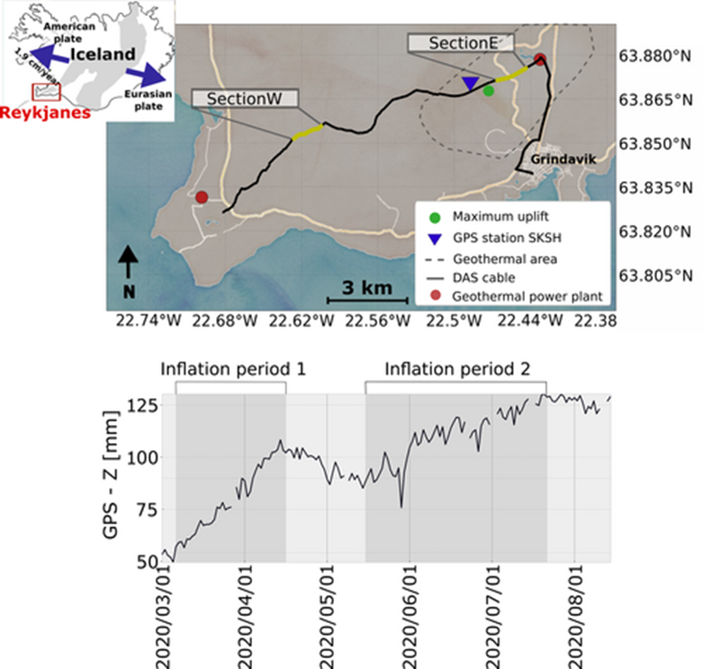
Figure: (Top) The DAS cable is located at the south-western edge of the Reykjanes peninsula (red square in the small map of Iceland). The selected fiber sections (SectionE and SectionW), the approximate location of the Svartsengi geothermal area, GPS station SKSH (Maass et al., 2024)
Measurements were obtained using an interrogator (Silixa system) with a gauge length of 10 meters, a spatial sampling of 4 meters and sampling frequency of 1000 Hz. Data is downsampled within the interrogator to 250 Hz, and transferred via internet in real time to analyse earthquakes and eruptions.
Read about it: Jousset et al., Sources of Ultra-Slow Dynamic and Static Deformation of dyke eruptive events revealed by telecom fibre optic cable sensing on western Reykjanes Peninsula, SW Iceland, EGU General Assembly 2025.
Since the beginning of SENSEI, two eruptions have already been measured and recorded. This activity will be the backbone and the reference for other techniques developed in SENSEI and tested in Iceland.
…more to come: stay tuned!