

 GO BACK
Iceland GeoSurvey (ÍSOR) is an Iceland-based international geothermal services firm focused on geothermal exploration, development and utilization. ÍSOR was established in 2003, when the Geoscience Division of Iceland’s National Energy Authority was spun off as a separate entity. As such, ÍSOR is a self-financing, state-owned, non-profit company that receives no direct funding from the government and operates on a project and contract basis, like a private company. ÍSOR is the leading provider of scientific and technical expertise to the geothermal industry in Iceland and abroad, with over two decades of experience in the field.
Imaging Iceland’s Subsurface Through Geophysical Insight
While the main focus at ÍSOR is on geothermal-related services, ÍSOR’s experience covers a wide range of geoscience-related fields and geoscientific research, such as geophysics, geology, and geochemistry. Geophysical activities for subsurface imaging include earthquake science, resistivity, magnetics and gravity – with earthquake science mainly focused on the operation of local seismic networks in active geothermal and volcanic fields in Iceland, and the subsequent analysis of passive seismic data.
Iceland’s Reykjanes Peninsula as one of the testbeds for the SENSEI project
ÍSOR joins the SENSEI consortium due to its longstanding collaboration with GFZ, the German research center for Earth sciences, over the years through various research projects. ÍSOR also has solid collaboration with Míla, Iceland’s largest telecommunications infrastructure operator, which runs fiber networks across Iceland, allowing for access to different fibers to be used and tested within the SENSEI project.
Another reason ÍSOR joins the consortium is the choice of Iceland as one of the SENSEI testbeds. Iceland is situated astride the divergent Mid-Atlantic plate boundary, separating the North American and Eurasian plates, and on top of the Iceland hotspot. As a result, Iceland – with its plate boundaries, rifts and transforms – is prone to earthquakes as well as volcanic and geothermal activity. It is one of the most active volcanic regions in the world, with eruptions occurring every three years on average.
For the SENSEI project, special focus will be placed on the Reykjanes Peninsula (RP) in southwest Iceland. It is the onshore continuation of the Mid-Atlantic Ridge, an oblique spreading zone with tectonic structure characterized by 6 en-echelon volcanic systems, and a total of 4 high-temperature geothermal systems identified from resistivity measurements. According to historical records of the last ~4000 years, 400-to-600 year-long episodes of volcanism and rifting are separated by 600-to-800 years of volcanic quiescence. The last volcanic rifting episode occurred 1200-to-780 years ago, and in 2021 a new volcanic rifting episode started with already 12 eruptions taking place within 5 years across two separate volcanic systems; 3 in Fagradalsfjall (2021-2023), and 9 in Svartsengi since late 2023.
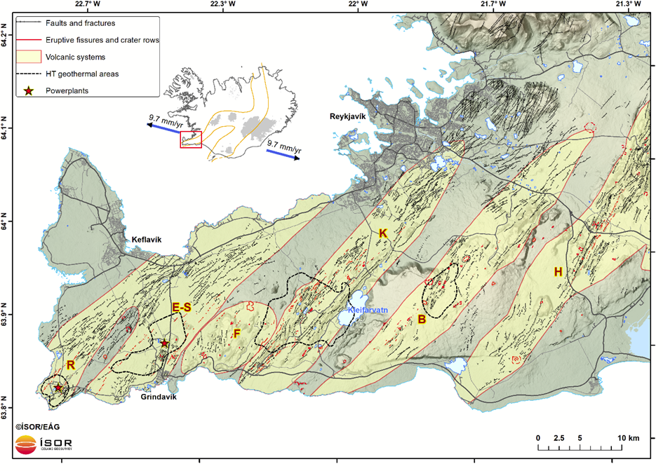
Reykjanes Peninsula in southwest Iceland: Volcanic systems are shaded light brown and marked with a bold letter (R: Reykjanes, E-S: Eldvörp-Svartsengi, F: Fagradalsfjall, K: Krýsuvík, B: Brennisteinsfjöll, H: Hengill); black dashed polygons show the extent of the high-temperature geothermal fields on the Peninsula according to resistivity measurements (summarized in Flóvenz et al. 2022) and the geothermal power plants of Svartsengi and Reykjanes are shown with red stars. Main roads are in black. The inset shows volcanic zones of Iceland (orange) with blue arrows indicating the plate spreading rate in Iceland (Sigmundsson et al. 2020). The red rectangle on the inset shows the location of the zoomed-in area.
During the last decade, a 15-km-long dark optical fiber, deployed in 1994 on the RP for telecommunications between the power plants of Reykjanes and Svartsengi, has been occasionally interrogated through the collaboration of GFZ, ÍSOR and Míla. This is the fiber where dynamic strain measurements were tested for the first time in real condition in Iceland in 2015 (Jousset et al., 2018). The fiber was again interrogated during the initial phase of the new volcanic rifting episode in 2020 (Flóvenz et al., 2022), and it has been interrogated almost continuously since late 2023 (Jousset et al., 2025).
Testing SENSEI’s Various Techniques in Iceland’s Dynamic Subsurface
Since the beginning of SENSEI, two eruptions have already been measured and recorded on this fiber, and we are currently waiting for the third eruption which might happen anytime now. Measurements are obtained using an interrogator (Silixa system) with a gauge length of 30 meters, a spatial sampling of 4 meters and sampling frequency of 1000 Hz. Data is downsampled within the interrogator to 200 Hz and transferred via internet in real time to analyze earthquakes and eruptions.
The fiber has special importance as it spans locations ranging from a large inflating/deflating magma domain near dike outbreaks at its eastern end, to a remote area where little signatures from eruptions are observed at its western end. For SENSEI, there are also other fibers available on the RP, which we plan to use. The already recorded activity will be the backbone and the reference for other techniques developed in SENSEI and tested in Iceland. Due to intense seismic and volcanic activity, a large variety of signals is expected to be recorded – from local earthquakes and eruptions to high-amplitude ambient seismic noise, intense storms, and anthropogenic signals.
…more to come! Stay tuned…